List of NationStates states
Corasa Island
Velka Volica Islands
- Velka Volica Wikimap
- Velka Volica Roadmap
- Velka Volica Public Transport Systems
- Velka Volica Administrative Division
- Velka Volica Airports
- Velka Volica Public Transport Simple Map
- Velka Volica Skyscrapers
Volican States
Maps of NationStates roleplay countries
NationStates is a text-based game and website in which users can create their own nation, set a flag, capital city and some other stuff after certain time milestones and solve issues by choosing one of prefered policies. Those policies affect dozens of statistics that makes up the classification of the nation's government, from Inoffensive Centrist Democracy to Psychotic Dictatorship.
The base game is pretty static, solving issues gets boring as you can't really build up your nation, you can just indirectly tweak up or down some arbitrary statistics, that don't make that much sense. The population number of the nation grows up every day by 1 million people if the nation is active at least once a 14 days. There is also a global organization, World Assembly where the nation can join and vote on various issues, even though they don't affect the nation's statistics at all.
The main selling point of NationStates however are regions. A nation can join one of the thousands of regions, that are groups of other players that can together role-play as multinational organization. Built-in regional forum can facilitate some simple role-plays, but the real advanced ones are using offsite apps, mostly Discord.
My first nation in NationStates was Tomeksovia, founded in 2013, and I didn't care about role-plays, just wanted my own website with my own flag and stuff. Every nation has a subpage with factbooks, articles that can be written in BBCode and able to simulate suprisingly complex semi-webpages that can mimic nation's Wikipedia.
All my NationStates projects are discontinued since September 2022 and all assigned NS nations cease to exist.
Corasa Island
Assigned nation in NationStates: Tomeksovia (formerly)
You see, the account on NationStates was first, and was called 'Tomeksovia'. After I revived that account for a bit I decided to make a map of that virtual state. I've made some drafts and I thought that the heart shaped map ('Corasa' is distorted word of 'Heart' in Spanish 'Corazon') is the best so I put those in Tomeksovia's NationStates factbooks and didn't bother to change names or something. Not confusing at all.
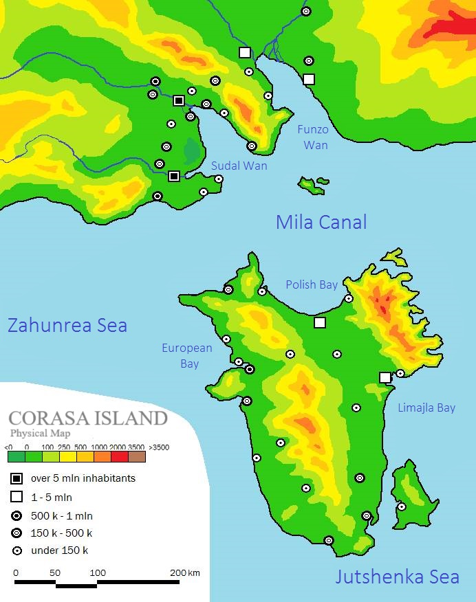
Corasa Island and part of a nearby
continent at the north
That map was my first successful attempt of digitalizing the contour
map drawn on paper, scanned and vectorized with GIMP.
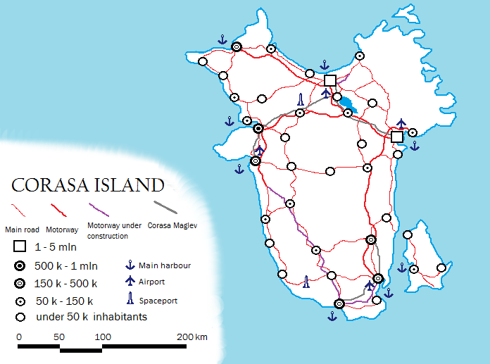
Corasa Island Road Map with other
points of entry
I don't even remember how I drew those roads and lines, I guess I used
combination of MS Paint (without layers) and GIMP (with layers which
was the main selling point for me). Funny how such a relatively small
country have two spaceports lol. Most of the cities didn't have a
label but some of them were actually named, but since the map wasn't
that useful, those names were used in another, much larger
worldbuilding project, which was New Volica, and later on
Volican States.
Velka Volica Island
Assigned nation in NationStates: New Volica (formerly)
For the sake of clarity (or not) I will try to call all the pitcher shaped island nation maps "Velka Volica", as the name "New Volica" was fully assigned to the two fingers shaped peninsula nation that is a member of Volican States. And I will fail at that because all those maps are signed "New Volica" so...
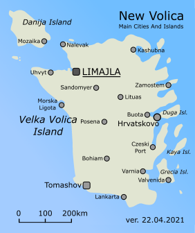
Velka Volica Islands - New Volica's
first version
After I abandoned Tomeksovia for a couple of years, I missed
NationStates for a while and started new state: New Volica. This time
around I made much more sophisticated maps as they were not rely on
GIMP layers, but Inkscape one.
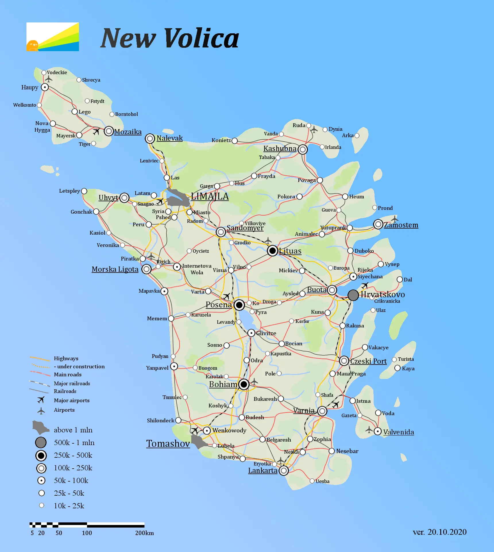
Velka Volica Road Map
That's the most epic map from the Velka Volica series, probably the
first public one in which I used the technique of drawing railways
with paths twice, the first layer is a bold black stripe and the
second on the top is a slightly thinner, white dashed line. This
technique was a fabulous discovery for me back then.
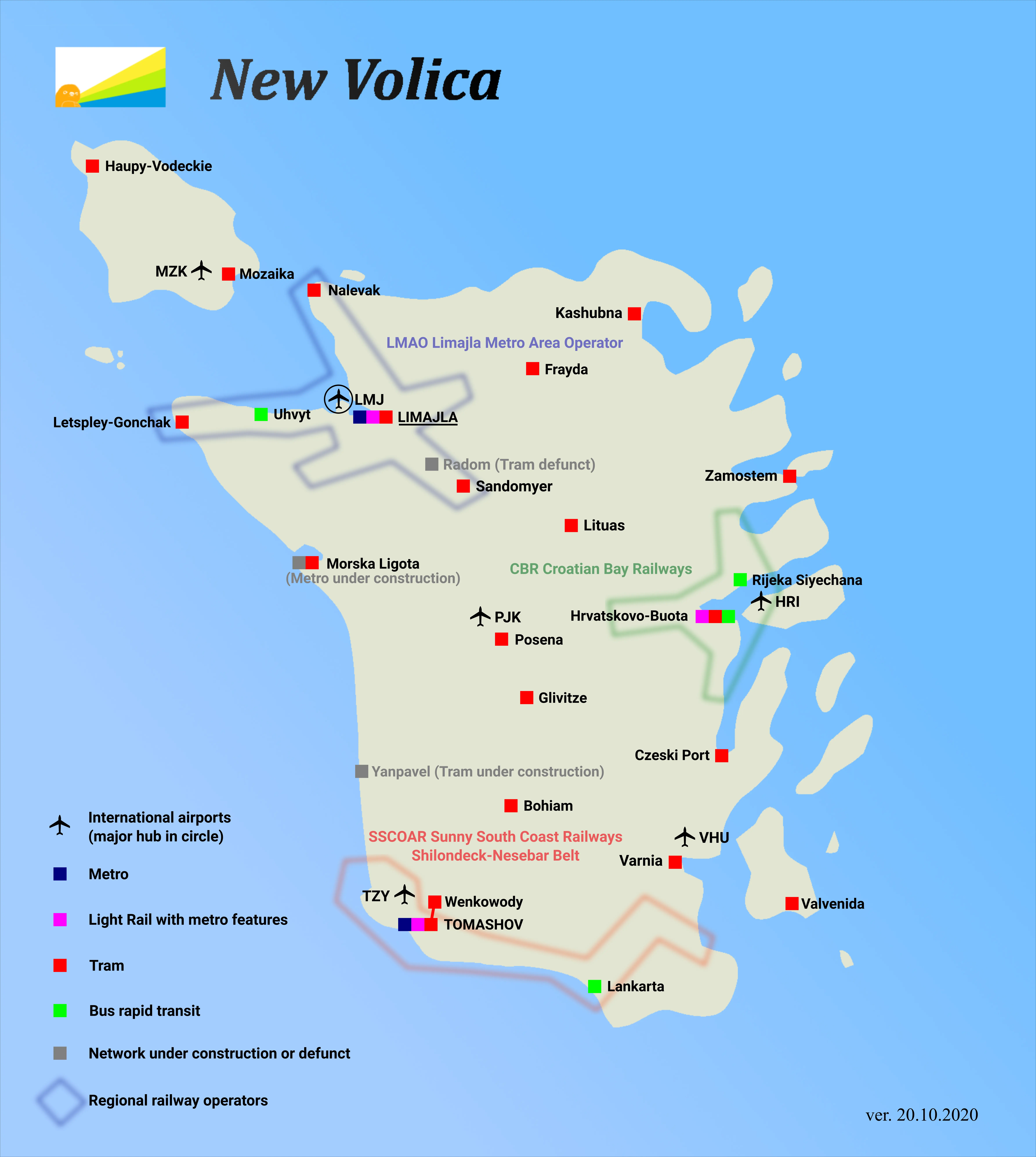
Velka Volica Public Transport Systems Map
UrbanRail.net is
one of my favourite website ever, as it have all the metro and tram
network maps of the entire world in one place, with consistent style.
It inspired me to make my own fictional maps like that, but to add
functionality I also designated extended transit networks that spans
multiple cities (tiny squares grouped with colorful shapes).
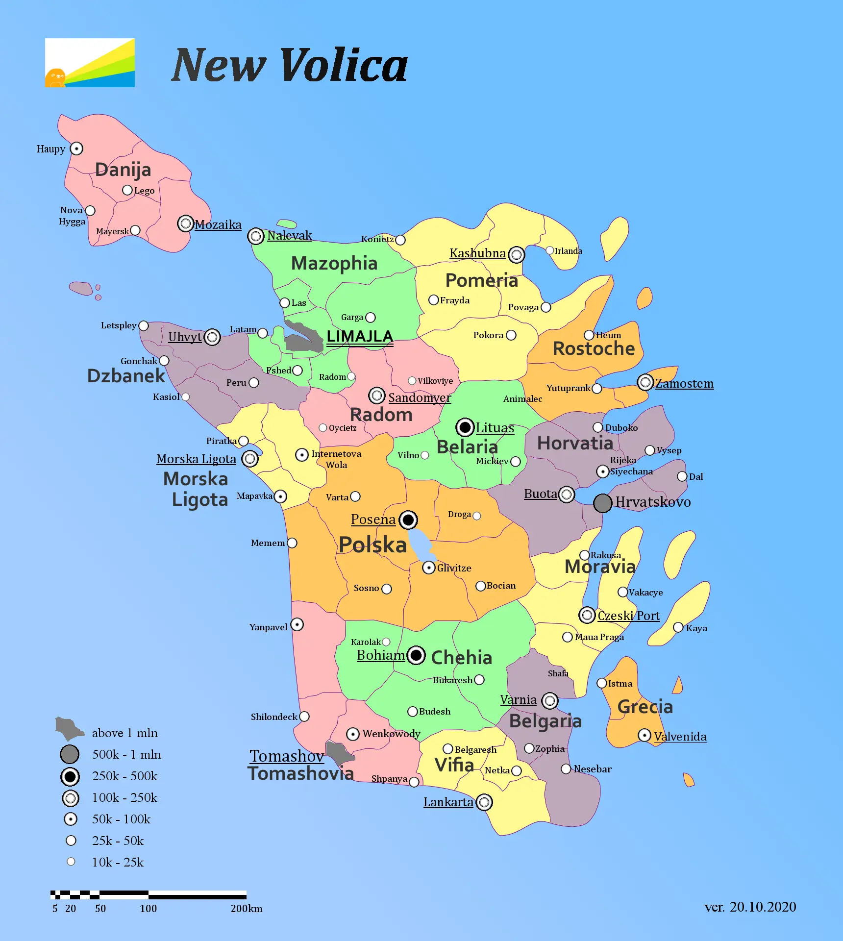
Velka Volica Administrative Division Map
Most regions were named after the real life places, except
Morska Ligota (can be translated as 'Marine Duty Free Place',
'Ligota' is archaic polish word), Mozaika ('Mosaic', of
course) and Dzbanek ('Jug', because the entire island kinda
looks like it).
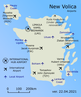
Velka Volica Airports Map
The global air transport is amazing and all theset systems, codes,
ground control, airports are super impressive. That's why I like maps
where major airports are located, they create invisible networks and
if they differentiate the number of passangers per year, the maps are
showcasing the true potential of the surrounding cities that they
serve. Here I guess I get lazy and there are just hubs, international
and local airports, missed opportunity that I fixed on next projects!
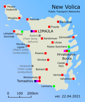
Velka Volica Public Transport Simple Map
Simpler map looked better as the thumbnail.
Velka Volica Skyscrapers Map
The map directly insired by a map of skyscrapers in Europe. It was
kinda fun to figuring out at first how to make those shadows in gimp.
Volican States
Assigned nations in NationStates: New Volica, Old Volica, Tomeksovia, Volica
- Volica Factbook - the main source document about the fictional states
- Volica Public Repository - public google drive that contains maps and other files related to the Volica and the world around it
- The Leftist Assembly - the region of NationStates.net that used to host and organize the Assembly of Nations roleplay which Volican States actively participated
Volican States Main Map
During the time of stay at home covid period, I got hooked into cobuilding a fictional world of Estia within the roleplay of Assembly of Nations. It used to be a leading roleplay of the region of The Leftist Assembly in NationStates.net and hosted on discord. For about a year I've become a leading cartographer of the planet of Estia and that made me to draw a bunch of various maps with Inkscape, learning some basics of QGIS and writing a staggeringly and unnecessarily detailed 130 pages long Factbook about my the most robust worldbuilding project so far, the country of Volican States! I've really enjoyed making maps for that world as well as writing the entire history for it and conduct foreign relations with other people, however my great desire was to develop a truly interactive and alive world maps but I've never acquired enough skills in GIS programs and web technologies to pull this off. The most I could get is to put a static image and wrapping it with leaflet.js and that didn't come without some major annoyances.
Detailed map of Volican States
So far it's my the best looking map (and image in general) made with
Inkscape.
Administrative division of Volican States
Volican States was actually meant to be a group of 7 almost completely
independent countries that were often hostile to each other. The
fragmentation of the land of Volicas was inspired by the real history
of Korean Peninsula and the break-up of Yugoslavia. The city of Blisko
acted as the capital of all Volican States, even though the status was
similar to that of Brussels for European Union, rather than typical
federated state capital. The main dividing force of Volica was the
conflict between communist Old Volica and capitalist New Volica (yeah
it sounds familiar) and the second one was how to pronounce
Volica - is the letter 'c' spelled like 'ts' or 'k'?. On
Volican Peninsula and nearby, four special administative regions that
belonged to foreign countries (my fellow roleplayers
Neo Enderion, Enderia, Xelebara and Krat)
were also designated as the Volican Peninsula was located in a very
strategic "700 km wide strait" between the oceans.
My first complete map of Volica
At first as I wanted to join the Assembly of Nations roleplay, I
wanted to embed my already estblished map of New Volica (Velka Volica
Islands) into the map of Estia. After my petition get rather negative
review I quickly chose the new place for New Volica, resurrected my
Tomeksovia NationStates account and added Old Volica, thanks to the
very obvious question of my fellow roleplayer Neo Enderion "Old Volica
where". In order to speed up my submission to the RP I created that
map in one day to show that I am worthy to join and my map making game
is strong.
Right after I started to expand the lore of Volica and
eventually added more states to Volica, from 3 at the beginning, to 8
states with their own governments, lore and competing interests.
Speeds on railroads of Volica - with
only 3 states
Fast and reliable railways were a key to compete economically with
train nuts from Neo Enderion, the country with extremely extensive
high speed railway network. Unfortunately I haven't done updated map
with all the Volican states, and that further confirms the
superiority of Neo Enderion, only in this regard of course, we
always had better work-life balance and more civil liberties!
Second level administrative division of Volican States
I'm really dissapointed that I never finished this map, I had some
issues with paths of second level subdivisions so I gave up adding
colors to the provinces, it would look much better. Anyhow, look how
cool are the names of provinces are, the capital of Old Volica is
Polska in Polska province (yeah).
Position of Volican States on the globe
The distances between the mainland Volica and their outlying states
are fairly large. That globe was made with QGIS but because the
program crashed often when I tried to make the globe with larger
resolution, it remained badly pixelated.
Satellite image of Volican States
That satellite image was made before the expansion of Volican States
with northern states of Arlavia and Kanalia, before my newer
neighbour Ruckya came into play and as well as before my
Varla neighbour across the strait made more detailed map with
cities. That's why the image is quite empty but I didn't bother to
make an updated one. Still, I like that style of the image, poorly
executed but kinda charming, made with GIMP.