Last version of the map: 6th April 2025
My first experimental map in OpenGeofiction
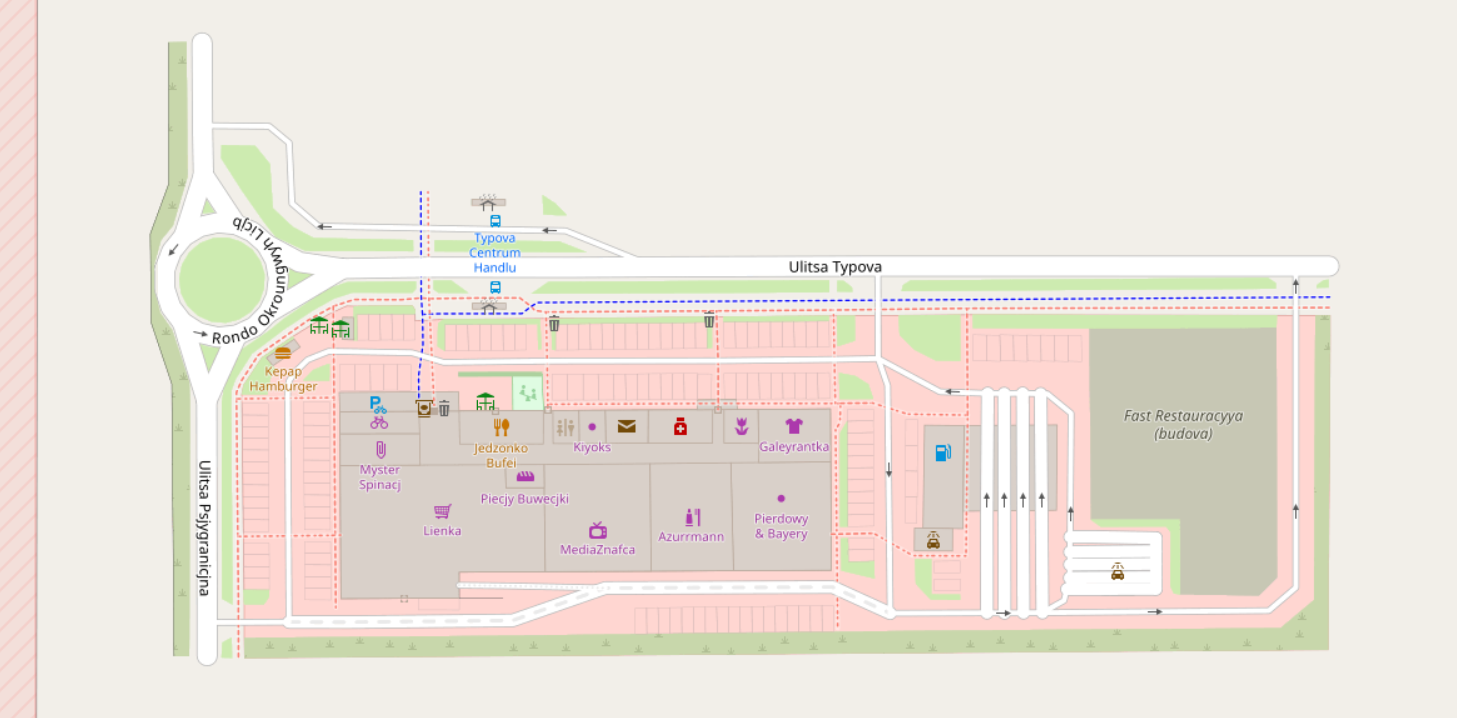
I called this place "Ministry of The Broken Lines Mall" as every line and shape that I draw is not that straight and finely aligned as it would take me hours to do so and I just wanted to whip something fast.
OpenGeoFiction is a collaborative worldbuilding project based on OpenStreetMap software, kinda like a Wikipedia of fictional universe, but with the focus on creating fictional map. This is a thing that I always wanted to be able to create on my own, but launching server like this is not a small feat. The maps that people are making there are very impressive, the participants often use JOSM to make them, a Java app that is much more advanced (and frankly hard to learn and set up on the computer) than in-browser ID editor. So far I was only able to dabble with ID on a playground part of the map where everyone (with an account) can draw something and get a gist of how it all works. The web editor is pretty straightforward, I could quickly draw some simple shapes and stuff with it, the map above is my very first project that is almost finished and complete.
For me the biggest disadvantage to use this kind of service to make fictional maps is that the software is set up perfectly to make maps based on aerial images and not draw something out of the head. It lacks convenient creators to make places like this for example, I wish I could just paste parking spaces rather than draw a single spot, then copy/paste it multiple times and carefully place them next to each other without making it all stupidly tilted.
Link to the location of my tiny little project:
Ministry of The Broken Lines Mall in OpenGeoFiction
the place is very much in the middle of nowhere :) You can check out more details by clicking on the right menu "Query Features" to see all the tags and names of selected object. It works just like OpenStreetMap which I highly recommend for everyone if you want to find out some hidden stuff on real life maps!
First entry on this page: 1st February 2025I'm editing this completely distracted on mobile, don't worry, it'll look normal soon lol
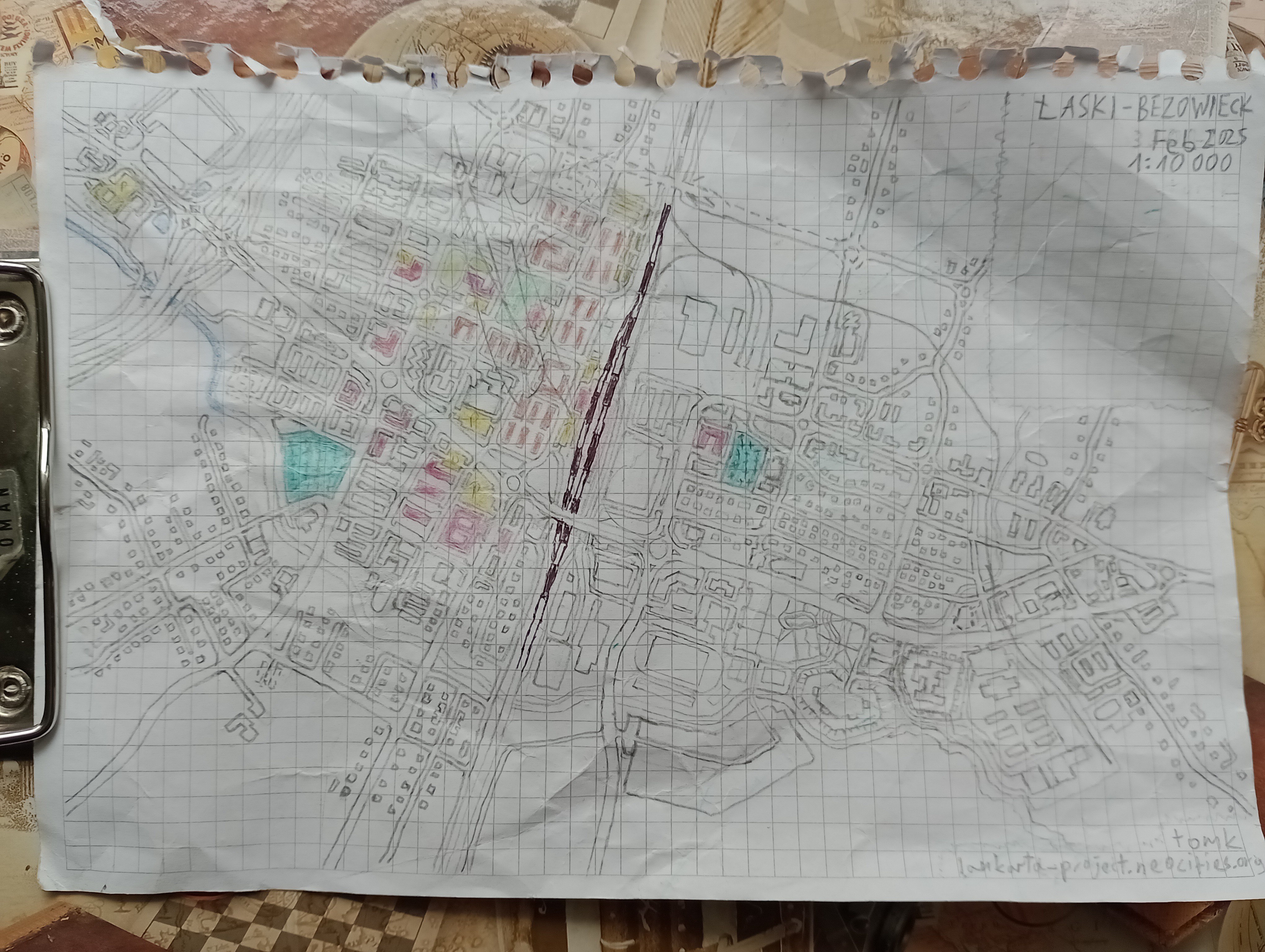
The twin city of Łaski-Bezowieck
That's my first fictional hand drawn map in 2025, which I didn't do in years. I was very close to finishing it completely but... it got destroyed by my sweet little vortex in diaper, so I gave up eventually. Still, I'm very pleased that my creativity is still there and can overcome lack of focus and all the obstacles including the fact that in the avalanche of kid toys and stuff I lost my automatic pencil with 0.5 mm slim graphite that would make that map a 100 times better.
This urban layout is directly inspired by various cities in the suburbs of large Polish cities that were built on the foundation of a major railway corridor, especially next to Warsaw and Łódź. The city is made of two parts separated by a railway.
The west side is Łaski - residential district with many apartment blocks and semi-detached houses, as well as the major hospital, a two elementary schools, a high school, a town hall and the largest shopping center. On the far west the highway is visible with the distribution center next to the diamond interchange.
The east side is called Bezowieck is older part with many industrial plants along the railway. On the southern side there is a more modern sport and cultural center with a large park. On this side there are a lot of rail branches including the longest one that goes to the jail and military camp next to the remains of the fortress.
The major unnamed river flows from the east to the west along the southern edge of both districts. Single houses are scattered around the core of the city.
The estimated population of the urban area is about 13 thousand people.